 CONFERENCE
LU Ģeodēzijas UN ĢEOINFORMĀTIKAS INSTITŪTĀ 2025. GADA JANVĀRĪ UZSĀKTA LZP FLPP PROJEKTA "Anomālās refrakcijas efekta izpēte izmantojot automatizēto digitālo zenītkameru VESTA" ĪSTENOŠANA
![]()
![]()
Šī pētījuma darba mērķis, kas raksturo tā novitāti, ir izpētīt anomālās refrakcijas (AR) uzvedību Zemes atmosfērā, izmantojot jaunu pieeju – digitālo zenītkameru (DZK) VESTA (VErtical by STArs) un atdalot AR komponentes no VESTA mērījumiem. DZK VESTA, radīta Latvijas Universitātē, nosaka Zemes gravitācijas lauka vertikāles nolieces komponentes izmantojot novērotos un zenīta zvaigžņu kataloga datus kā augstas precizitātes atskaites sistēmu. VESTA veic tiešus augstas precizitātes mērījumus, kas ir neatkarīgi no gravitācijas paātrinājuma, ģeometriskās nivelēšanas, ģeoīda virsmas slīpuma. Esošā pieredze rāda, ka AR tiek novērota kā kļūdu avots visās DZK mērījumu kampaņās, ierobežojot novērojumu precizitāti. Testa mērījumu veikšana dažādos vides apstākļos ar divām tuvu esošām DZK un meteoroloģisko sensoru tīklu dos iespēju izpētīt anomālās refrakcijas fenomenu un sniegt rekomendācijas AR ietekmes mazināšanai.
Ģeodinamika un Ģeokosmiskie Pētījumi 2024
Ar prieku uzaicinām Jūs uz kārtējo LU GGI organizētu starptautisku zinātniski tehnisko konferenci "Ģeodinamika un ģeokosmiskie pētījumi 2024".
Konference tiek organizēta LU 82. starptautiskās zinātniskās konferences ietvaros un notiks 29.05. - 30.05.2024. Latvijas Universitātes Zinātņu mājā Jelgavas ielā 3, konferenču zālā "Alfa". KARTE
Šobrīd darbs pie konferences programmas veidošanas ir teju noslēdzies un ir zināms, ka konferencē piedalīsies ziņotāji gan no Rīgas Valstspilsētas Pašvaldības, Latvijas Ģeotelpiskās Informācijas Aģentūras, Valsts Zemes Dienesta, Zemkopības Ministrijas Nekustamajiem īpašumiem, Mērniecības datu centra, Latvijas Valsts Mežiem un citām iestādēm un uzņēmumiem.
Tuvākajā laikā tiks atvērta arī reģistrācija konferencei, lūdzam sekot līdzi jaunākajai informācijai.
Konferences programmā tiks iekļautas tādas tēmas kā:
-
Ģeodinamika un ģeokosmiskie pētījumi;
-
Gravitācijas lauks, ģeoīda modeļi un augstuma sistēmas;
-
Astroģeodēziskie mērījumi;
-
GNSS un satelīt-ģeodēzija;
-
Nivelēšanas tīkli;
-
Mērniecības risinājumi;
-
Fotogrammetrija, attālā izpēte;
-
Ģeogrāfiskās informācijas sistēmas;
-
Bezpilota lidaparāti;
Konference sastāvēs no sekojošām sekcijām:
29.05.2024. REĢISTRĀCIJA
Profesionāli tehniskā konference. Ziņojumus šajā konferences daļā sniegs valsts politkas veidotāji ģeodēzijas un ar to saistītajām nozarēm un šīs jomas pārstāvji no profesionālajām aprindām. Konference notiks Rīgā Jelgavas ielā 3, Latvijas universitātes Zinātņu mājā, Konferenču zālē Alfa. Darba valoda - Latviešu
Šogad, profesionāli tehniskajā konferences daļā uzsvars tiks likts uz ģeotelpisko datu publicēšanas platformām un lietotnēm, kas atvieglo nozares profesionālu ikdienu.
30.05.2024. REĢISTRĀCIJA
Starptautiska zinātniskā konference. Konferencē sniegto ziņojumu tēzes tiks publicētas tēžu krājumā. Konference notiks Rīgā Jelgavas ielā 3, Latvijas universitātes Zinātņu mājā, Konferenču zālē Alfa. Darba valoda - Angļu.
Lai iegūtu sīkāku informāciju un reģistrētos konferencei, lūdzam apmeklēt konferences mājas lapu: GGP2024
Geodynamics and Geospatial research 2023
International scientific conference of the LU GGI
Its our pleasure to announce and after a three year break invite you to the international scientific conference of the Institute of Geodesy and Geoinformatics of the University of Latvia "Geodynamics and Geospatial research 2023"
Within the framework of 81st international scientific conference of the University of Latvia, Institute of Geodesy and Geoinformatics are organizing section - Geodynamics and Geospatial research 2023.
Conference will take place on 1st of June 2023 at the House of sciences of the University of Latvia in conference hall Alfa, located in Jelgavas street 3, Riga, Latvia. MAP
Work language of the conference - English.
Abstracts of the presentations will be published in abstract book.
There is no participation fee for the conference. The registration will open shortly, please follow the latest information.
Deadline for the speaker registration and submission of the abstracts is 20th of May 2023.
Abstracts can be submitted preferably via INDICO system HERE (registration necessary). In case of difficulties abstract can be uploaded (not preferable) during the registration process HERE.
Deadline for the participant registration is 25th of May 2023.
Recommended topics but not only for the conference are:
-
Geodynamics and geospatial research;
-
Gravity field, Geoid models and height systems;
-
Astrogeodetic measurements;
-
GNSS and satellite geodesy;
-
Leveling networks;
-
Survey Engineering;
-
Photogrammetry, Remote sensing;
-
Geographical Information Systems (GIS);
-
Unmanned aerial vehicles (UAV);
For more information, registration and abstract submission please visit Conference home page: https://conferences.lu.lv/e/ggr2023
IN JANUARY, TWO NEW POST-DOCTORAL RESEARCH PROJECTS ARE BEING STARTED AT THE INSTITUTE OF GEODESY AND GEOINFORMATICS:
"Reconfigurable space object optical tracking system of GGI – implementation stage", project supervisor, senior researcher Dr.sc.ing. Diana Haritonova. The project objective is to install and configure the optical tracking system of the Institute of Geodesy and Geoinformatics (GGI) and start its exploitation using for positional astrometric observations. The project will facilitate radical changes in the development of the optical system, bring new knowledge and skills to the post-doctoral researcher.
"Investigation on accuracy improvement of automated zenith camera's VESTA deflection of vertical measurements", project supervisor, senior researcher Dr.sc.ing. Inese Varna. The project objective is exploring the potential of new automated digital zenith camera (DZC) VESTA (VErtical by STArs): 1) by testing it in various environments for investigation of anomalous refraction effect; anomalous refraction is the main limiting factor of ground-based astrometric observation’s precision, causing irregular angular displacements of observed stars; 2) performing accuracy analysis in test site over 2 years to estimate spatio-temporal properties of measured gravitational deflection of vertical (DoV) values.
AGU FALL MEETING 2019
Laikā posmā no 9. -13. decembrim Amerikas Savienotajās Valstīs, Sanfrancisko ir norisinājies pasaulē lielākais starptautiskais Zemes zinātņu un kosmisko zinātņu forums - AGU Fall Meeting 2019, kurā piedalījušies dalībnieki no 106 valstīm ar ~26000 referātiem. Ģeodēzijas un ģeoinformātikas institūta pētniece Katerīna Morozova ir piedalījusies ar tēmu "Digital Zenith Camera for Vertical Deflection Determination: on the Way to 1 cm Precise Quasi-Geoid Model for Latvia", kas izraisa milzīgo interesi no amerikāņu kolēģiem no Teksasas universitātes, NGS, NGA organizācijām, kā arī citām valstīm (Somija, Dānija, Mongolija utt.). Digitālā zenītkamera ir unikāls instruments, kas izraisa arvien lielāko interesi starptautiskajā līmenī.
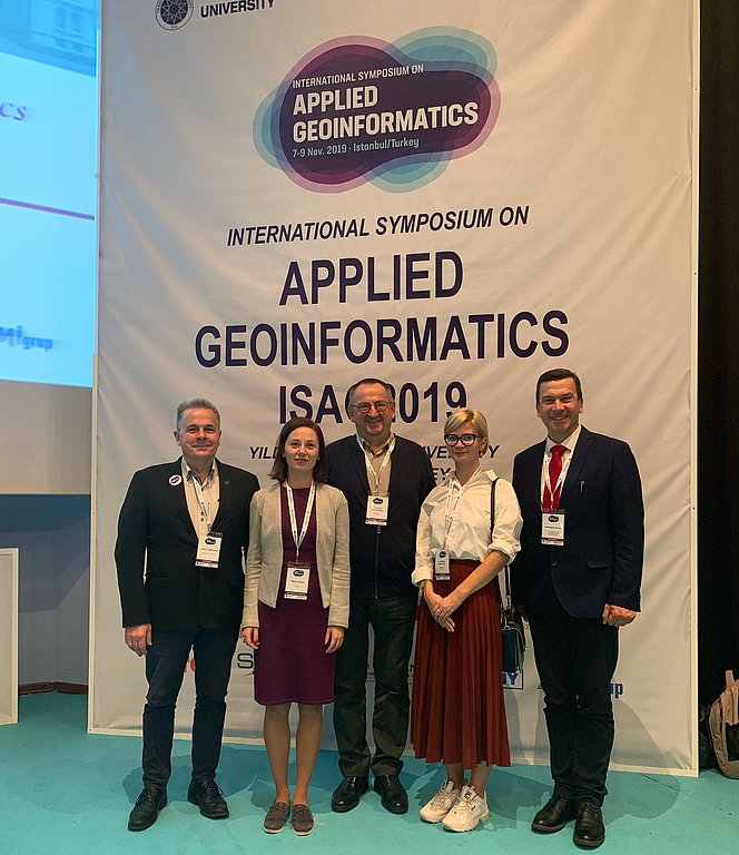
International Symposium on Applied Geoinformatics
Latvian delegation took part in Yildiz Technical University and University of Latvia commonly organized International Symposium on Applied Geoinformatics, which was held in Istanbul, Turkey, 7.11.- 9.11.2019. Institute of Geodesy and Geoinformatics performed the Digital Zenith Camera, SLR device, as well as other activities, which are going on in the institute. In the year 2021 International Symposium on Applied Geoinformatics will be held in the University of Latvia, and will open its doors for participants.
VESTA reaches LSU
GGI director dr. sc. ing. Gunars Silabriedis and lead researcher dr. phys. Ansis Zarins returned back from Louisiana State University, USA, where they led a successful workshop for the colleagues on the deflection of vertical determination using astro-geodetic technique - Digital zenith-camera, presenting both theoretical and practical course. The development of digital zenith camera and data processing software was finished by GGI staff in 2016 and since than arouse international interest in geodetic society. More photos can be found in the gallery.


1st International Symposium on Applied Geoinformatics
Institute of Geodesy and Geoinformatics, University of Latvia and Department of Geomatics Engineering, Yildiz Technical University (Istanbul, Turkey) jointly organises 1st International Symposium on Applied Geoinformatics (ISAG2019). Symposium will be held on November 7-9, 2019 in Istanbul, Turkey.
The symposium is organised with the aim of promoting advancements in the field of Geoinformatics.
More information about symposium, registration etc., can be found on the home page: www.isag-2019.yildiz.edu.tr
We look forward to welcoming you in ISAG2019!

The development of new Digital Zenith-Camera
The scientific staff of Institute of Geodesy and Geoinformatics sucessfully finished digital zenith camera, which allows to detrmine plumb line directions. The Zenith Camera is now on its way to the USA, Loisianna State University, who ordered the instrument for their scientific needs.


EUREF 2019 Symposium
The EUREF 2019 Symposium took place on May 22-24, 2019 in Tallinn, Estonia. Leading researcher dr. sc. ing. Inese Varna presented her research on topic "Latvian CORS Time Series Analysis for 2011 - 2018". The poster can be found here.

European Space Agency "ESA Living Planet Symposium"
European Space Agency Symposium was held in Milan, Italy, May 13-17, 2019. Dr. sc. ing. Diana Haritonova has presented her reaserch: "The Impact of the Baltic Sea Loading on GNSS Station Coordinate Time Series: the Case of Latvia". The Poster can be found here.
University of Latvia 77th International Scientific Conference "Geodynamics and Geospatial Research 2019"
77th International Scientific Conference "Geodynamics and Geospatial Research 2019" was organised by the scientific staff of GGI, where project results were presented at international level: besides Latvian scientists, colleagues from Estonia, Lithuania, Poland and Germany were also participating and presented their research. The conference was held in Riga, March 20-22, 2019.
NKG working group: Geodynamics and Earth Observations
NKG working group "Geodynamics and Earth Observations" meeting was held in Copenhagen, Denmark, March 12-13, 2019. Dr. sc. ing. Diana Haritonova took part in it and presented her research on the topic "The Impact of the Baltic Sea Loading on GNSS Station Coordinate Time Series in the territory of Latvia". Presentation can be found here.
The 5th EUPOS council meeting
On 14th-15th of November, 2018, the 5th EUPOS council meeting was held in Tallinn, Estonia. New managements were elected for period 2018 - 2022.
As EUPOS chair was elected:
Branislav Droščak
For EUPOS Executive Board were elected:
Ambrus Kenyeres
Ingus Mitrofanovs
Szymon Wajda
Jaroslav Šimek
Jan Reznicek
As vice-chair of EUPOS senior researcher of LU GGI Dr.sc.ing. Ingus Mitrofanovs was nominated.
Geodetic Week and InterGEO 2018 exhibition
InterGEO was held in Frankfurt-on-Main, Germany, October 16-18, 2018. GGI researcher has presented both project results and scientific software developement for gravity field and quasi-geoid determination. The title of presentation is “QGeoid Computation of Western Part of Latvia, Parameter Estimation and Optimization Concepts for Gravity Field Determination” and it can be found here.
International Symposium Gravity, Geoid and Height Systems 2 "Gravity Field of the Earth"
International Symposium Gravity, Geoid and Height Systems 2 was held in Copenhagen, Denmark, September 17-21, 2018. The project results on a topic "Preliminary results on Quasi-geoid of Latvia using Vertical Deflection observations" were presented by GGI researcher Katerina Morozova. The presented poster can be found here.
Nordic Geodetic Commission General Assembly
Nordic Geodetic Commission General Assembly was held in Helsinki, Finland, September 3-6, 2018. Leading reseacher dr. sc. ing. Inese Varna and researcher Katerina Morozova took part in it and presented two poster presentations on project results:
I. Varna "Velocity Fields of the Latvian CORS Station Daily Coordinates for 2012-2017" poster presentation can be found here.
K. Morozova “Preliminary results on qgeoid for Western part of Latvia using Digital-Zenith camera and DFHRS software” poster presentation can be found here.
